In the list below you can find general info and the distances form Sete to ‘West’ destinations, a.o. Roussilon, Cap Bear, Costa Brava, Costa Dorada and the Baleares, (Islas Baleares).
Some trips are daytrips, distances between 25 to (max.) 70 NM (one way) can de done in one day, depending on wind (and wind direction).
others can de done in a short week, some trips are only possible if a period of more weeks is scheduled.
Herault / Aude
Cap d’Agde , low and rocky, is located 9.5 miles ENE of Valras-Plage. Montagne du Gros Frere, 848m high, stands 29 miles N of the cape and may be sighted on a clear day from a considerable distance to the S. Mont d’Agde, 115m high, stands 1.5 miles NNW of the cape. It is isolated and conical and can easily be identified at a distance of 12 miles.
Between the cape and the mouth of the River Herault, 3 miles W, the coast is fronted by rocks and rocky points. Pointe de Roche Longue, located midway along this stretch, is surmounted by an old battery. Two radio masts stand 1 mile N of the battery and are prominent.
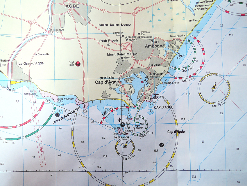 Port Cap d’Agde is a huge Marina where you can find all parts for your boat and work on your boat in the zone technique.
The town of Agde is situated 2 miles above the entrance to the River Herault and is fronted by depths of 3 to 6m. Small craft with local knowledge use the river.
Le Grau d’Agde, where the Herault ends in the sea, has a small harbor and lots of moorings at the river beds, is situated close W of Cap d’Agde. It is protected by two breakwaters and used by yachts and fishing craft.
Ilot Brescou, formed by a flat rock, lies 1 mile SW of Cap d’Agde and is surmounted by the grey structure of Fort Brescou.
A light is shown from a structure, 11m high, standing at the S corner of the fort. This islet is surrounded by dangers and foul ground.
Port Ambonne, a small yacht harbor, is situated 1.2 miles NNE of Cap d’Agde and is protected by two breakwaters.
Port Marseillan Plage, a small harbor, lies 2 miles NNE of Port Amboune and is protected by two jetties. A canal, with a depth of 2m, connects the harbor with Etang de Thau, a lagoon.
Quilles, a small yacht harbor, is situated 6.5 miles NE of Port Marseillan Plage. It lies on the SW side of Mont Saint Clair and is protected by breakwaters. The coast between consists of a low and narrow beach which separates Etang de Thau from the sea. A range of hills stands on the N side of the lagoon.
During W and NW winds, vessels can anchor, in 5 to 6m, sand and rock, poor holding ground, ENE of Cap d’Agde.
Several prohibited areas (fish havens), the limits of which may be seen on the chart, lie NE of Cap d’Agde and are marked by lighted buoys.
A prohibited anchorage area, marked by lighted buoys, lies about 1.2 miles SE of the harbor entrance.
Valras-Plage, a resort, is situated at the mouth of the River Orb, 6.5 miles NE of Rocher St. Pierre. A yacht and fishing craft harbor is situated within the river mouth. A casino and a large water tower stand in this vicinity and are excellent landmarks from seaward.
Port de Narbonne-Plage, an extensive yacht harbor, is situated 4 miles NE of Gruissan-Plage and is protected by two breakwaters. A rectangular prohibited area lies 3 miles E of the harbor entrance.
Rocher St. Pierre , located close NE of Port de Narbonne-Plage, is 5m high and surmounted by the sand-covered ruins of a battery. It is the most distinctive mark in this vicinity. A prohibited area, marked by lighted buoys, lies E of Rocher St. Pierre.
A conspicuous radar tower, 25m high, stands 3.2 miles W of Rocher St. Pierre and is surmounted by a dark green dome.
Gruissan an extensive yacht harbor, is situated 3.5 miles NNE of Grau de la Vieille Nouvelle and is protected by two moles, A prohibited area, the limits of which are marked by buoys, lies centered 1.5 miles SE of the harbor entrance.
A submarine pipeline extends 2 miles ESE from a point on the shore, 1.2 miles NNE of Gruissan-Plage.
Le Pech Rouge, a shoal patch, lies nearly 1 mile NE of the root of this pipeline and is marked by a lighted beacon.
Distances
Sete. Cap d’Agde. 11
Sete. Valras. 20
Sete. Gruissan 40
Roussilon
From Presqu’ile Saint-Vincent to Cap Leucate, 24 miles N, the bottom is generally formed of sand, or sand and mud.
Fog is frequent along this stretch of coast, particularly during E winds. In bad weather it is advisable for vessels to navigate in depths of more than 25m.
Fishing and yacht harbors are situated at Massane, Saint Cyprien, Canet-Plage, Barcares de Saint Laurent, Grau Saint Ange, and Port Leucate, which lie 1.8 miles, 6 miles, 11 miles, 16 miles, 16.5 miles, and 23 miles N, respectively, of Presqu’ile Saint-Vincent.
Port- Leucate, by its port area, the largest marina in Europe. Its capacity is 1300 boats. major development projects will be made in the coming years .
Two large basins protect boats with a draft up to 3 m:
– The south basin , with its quay of honor, is located in the heart of Port Leucate close to shops and summer events .
– The North Basin , calmer, home to many Bayeaux inhabited year-round . This is where the technical area , shipyards , and the captainery are situated.
3 travelifts including a 50 t and a dock 6.8 m working width ( the largest in the Languedoc- Roussillon ) allow the handling of large units . The speed limit is 5 knots in the outer harbor and 3 knots in the basins .
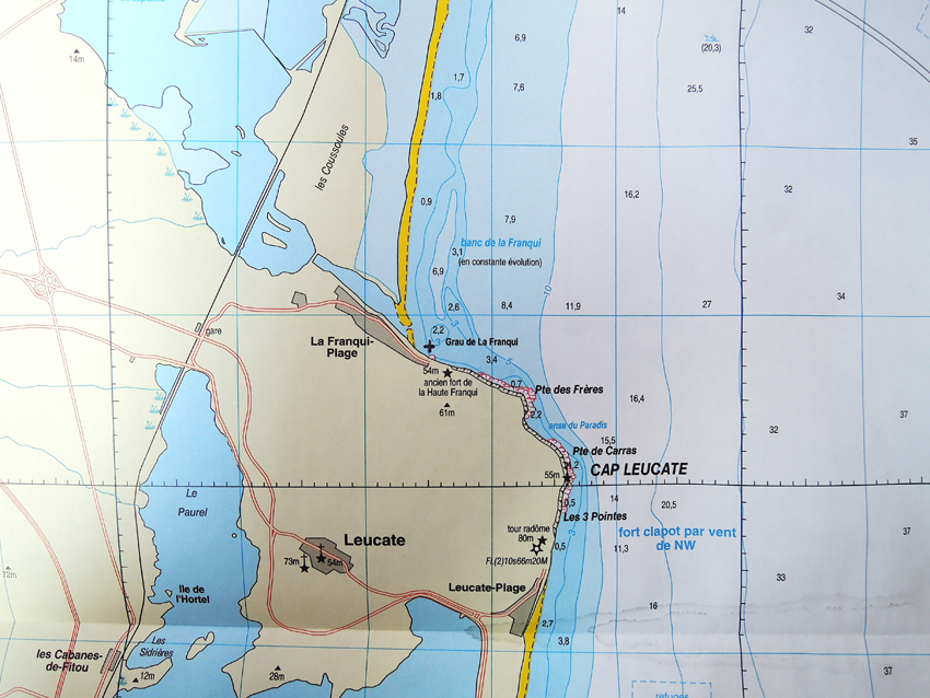
Anchoring possibility at La Franqui, North of Port Leucate
CAPITAINERIE
Technical area of the marina of Port Leucate , central basin,
Season: open from 8 am to 19:30 ; night surveillance with accommodating ships
Off season: 8h -12h and 14h -18h
V.H.F. Canal 09
Tel. : 04.68.40.91.24
Fax. : 04.68.40.72.27
Email: capitainerie@port-leucate.fr
Canet en Roussilon. A few miles from the coves, close to a fine sandy beach, the port of Canet-en-Roussillon provides visitors with total peace and comfort. Within easy reach of all facilities, the warfs are protected by an iron gate with a bolt and by video watch. Here the marina can receive boats up to 25m long. The mooring system presents all the guarantees to allow the entrance and exit in high wind. With the ‘escale privilège’ pass, 3 consecutive stopovers nights secure free entry to numerous cultural and sporting facilities.
Saint Cyprien Under the Mediterranean sun, the long fine sand beach of Saint-Cyprien highlights the deep blue sea, under the majestic heights of mount Canigou. While the recently developed station of Saint-Cyprien’s reputation for sports and outdoor leisure activities derives from the modernity of its top quality facilities, the station nevertheless remains deeply rooted in a strong popular and artistic tradition. In Roussillon on the Spanish border, the station has attractions both on land and at sea.
Port-Vendres takes its name from Portus Veneris, the port of Venus, France’s last deep-water port, situated on an attractive rocky coast at the heart of a traditional Catalan citadel whose port activities keep it buzzing with life all year round. Port-Vendres marina is a greatly appreciated stopover for lovers of ocean navigation. It provides good shelter from sea and swell.The strongest winds in this vicinity are those from the NW, E, and SE. Storms often accompany strong E and SE winds. The high hills, which rise abruptly near the harbor, generally shield the area, but strong NW winds sometimes sweep through the gap in these hills and hinder navigation.
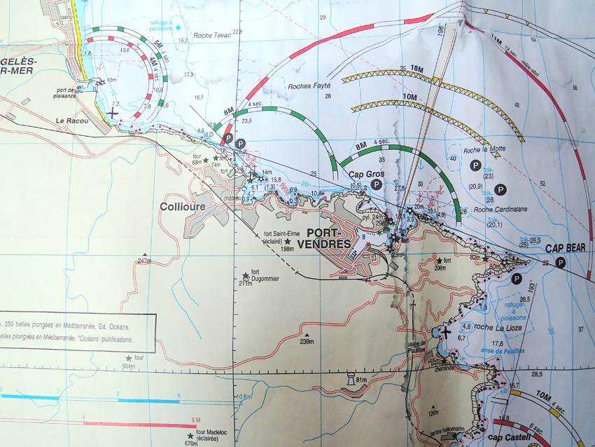 Off the port, the general set of the current is SE and it may attain a velocity of 5 knots after a long period of strong N winds. Even with strong winds against it, a velocity of 2 knots may still be maintained. However, the effect of the current is not felt more than 1 or 2 miles seaward of the harbor.
Mole Abri, a breakwater, extends 250m NW from the shore. The harbor is entered between the head of Mole Abri and Pointe du Fanal, 300m SW. A yacht basin is situated in the S part of the harbor.
There is 798m of total commercial quayage, with depths of 6 to 8m alongside, and facilities for ro-ro vessels. Vessels up to
155m in length and 8m draft can be accommodated.
Aspect.—The harbor lies at the foot of the E ranges of the Pyrenees, and vessels approaching from seaward in fine weather can distinguish these mountains from a great distance. The coast to the N of the harbor is low and flat.
Prominent landmarks include Fort Saint-Elme, which stands on a hill 0.5 mile W of the harbor, and Redoute du Fanal Light, which stands on the W side of the harbor entrance.
A lighted range indicates the entrance channel. The front mark, which is difficult to distinguish by day, is a red pillar on a white base. The rear mark is a square tower with a red roof bearing a stripe in the middle, with red and white squares.
Distances
Sete. Cap Leucate. 40
Sete. Canet en Roussilon. 50
Sete. St. Cyprien. 55
Sete. Port Vendres. 58
Sete. Cap Bear. 58
Costa Brava
The Costa Brava is the name given to the Spanish coast on the Mediterranean Sea, north-east of Catalonia, in the province of Girona. It starts from the French border, Portbou, S Cape Cerberus, and extends over 70 km to Blanes.
Climate:
Sweet in winter, hot in summer, the climate of the Costa Brava is typically Mediterranean. In summer, temperatures often exceed 30 ° C at midday along the coast.
The most pleasant time to surf is from April to October.
The water temperature in summer is around 26 ° C.
Prevailing winds are from the South West and North West force 2 to 4.
Prevaling winds
Geographical location and orography of the Costa Brava are such that,
depending on the period, different winds travel different sectors of the coastline. The summer breezes are common all along the coast, the most notable being those of the Bay of Roses. The famous Tramontana affects fundamentally the north, where it can blow violently as one moves away from the coast, whose cut profile has always sheltered places. The gregal comes also from the north and can blow at intensities very greatly from one sector to another, even very close. Offshore winds or ponant, frequently at night after a day of strong wind, are lightweight and make very nice stops in the best coves.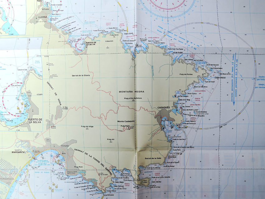
Distances
Sete. Cala Garvet (SP) 64
Sete. Port de la Selva (SP) 67
Sete. Cabo Creus. (SP) 66,5
Sete. Port LLigat. (SP) 68,5
Sete. Cadaques. (SP) 70
Sete. Cala Montgo. (SP) 81
Sete. Estartit. (SP) 83
Sete. Islas Medas. (SP) 83,5
Sete. Cala St. Pol. (SP) 102
Sete. Arenys de Mar. (SP) 128
Islas Baleares
The Balearic Islands (Catalan: Illes Balears; Spanish: Islas Baleares) are an archipelago in the western Mediterranean Sea, near the eastern coast of the Iberian Peninsula. They form an autonomous community and a province of Spain, of which the capital city is Palma de Mallorca.
The main islands of the autonomous community are Majorca (Mallorca in Spanish), Minorca (Menorca), Eivissa (Ibiza), and Formentera, all of which are popular tourist destinations.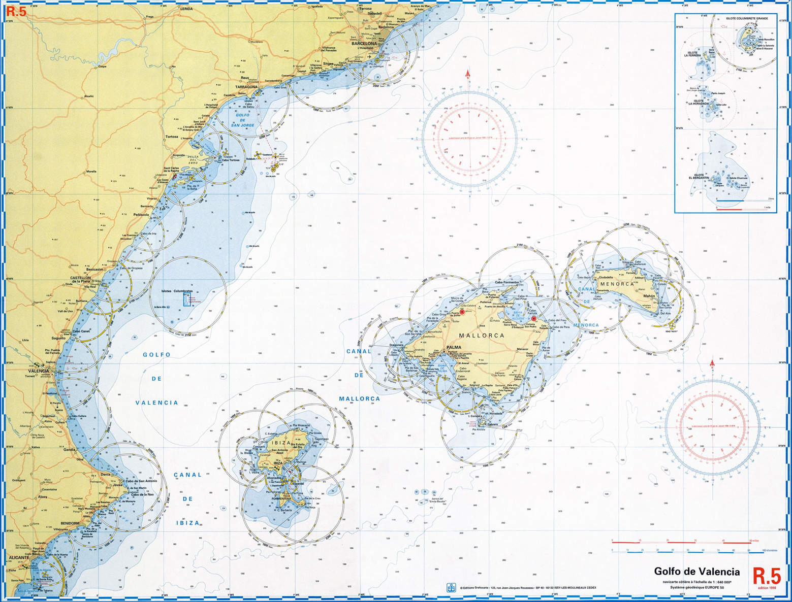
Distances from Sete
Sete. Cabo Formentar-palma NO 207
Sete. Soller Palma W 220
Sete. Pta. S’Aguillo – Cabo del Creu-Palma E. 220
Sete. Puerto Del Fangal – delta Ebre 225
Sete. Denia. 234
Sete. Formentera – Isla Espalmador 294
Sete. Punta del Mares Ibiza 276